The industry standardfor finding primeEV charging sites
Find and deploy sites with confidence. Station utilization data, to-scale layouts, and cost estimates, packaged into a shareable report in minutes.
Access utilization data for over 85% of stations in the US
Design charging sites in minutes, zero training required
Recommended by members of the Tesla Supercharger team
Trusted by half of the EV charging industry
“What once took an hour per project can now be completed in just minutes. Overall, EVpin has empowered our team to move faster, with greater confidence.”
Brad Norman
Sr. Sales Engineer at ChargePoint
You shouldn't need to open 18 tabs to qualify one charging site
From scouting a location to sending the final report, EVpin keeps the proposal process connected and moving forward.
No more 18 open tabs.
One tool. From scouting to signed proposal.
Everything you need and more to evaluate charging sites.
Scout locations, compare station-level utilization data, evaluate site scores, and create polished site reports in minutes.
13332 Express Wy
Los Angeles, CA 90001
AHJ data
Find the authority having jurisdiction for any address so you know the permitting requirements in advance.
Property contact info
Pull contact information for parcels with a click. Every contact you pull is visible to you and your entire team.
Utility company
Identify the serving utility at any address to scope interconnection cost and timing early.
Filter stations
Filter existing chargers by network and speed to size up competition before you commit.
Driving direction
Get driving directions to nearby stations, retailers and highway exit around your site in just a couple of clicks.
Crime rates
Review crime data by area to flag operational risks before they hit your maintenance budget.
See the full picture,
one map layer at a time
Overlay spatial data directly on the map to understand what surrounds each site, spot patterns, and vet sites with confidence.
Utilization (last month)
Disadvantaged communities
Find out if your site qualifies as a disadvantaged community under the EPA IRA or Justice 40.
Median income
Explore median income data for any region or zip code throughout the US and Canada.
Power service areas
View the coverage map for every electric utility company in the US and Canada.
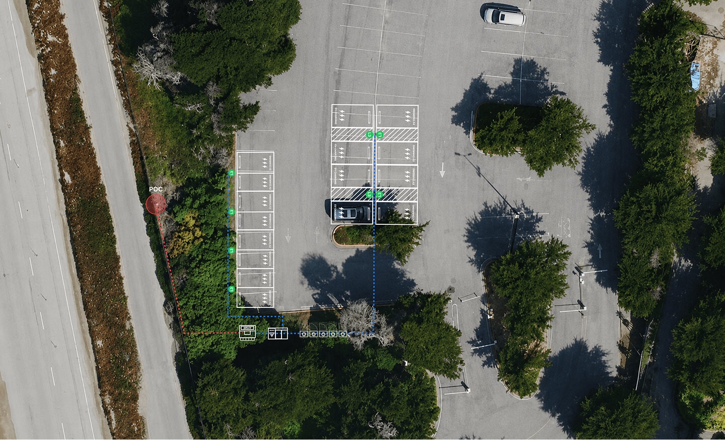
Design your next station live,
with your team
Comment, mark up, and iterate together. Every change syncs in real time so your team designs as one.
Sam
Jake
Every step from sketch to signed proposal
Take a site from first sketch to signed proposal without leaving EVpin. Every step lives in one workspace.

Sam
Import a CAD or PDF and lay out chargers directly on the architect's drawing.

1'
Charger → H-Frame
Jake
Draw underground runs and watch length, voltage drop, and trench cost update as you go.
Every charger, trench foot, and permit line rolls into one running total.

Los Angeles, CA
$345,000
Austin, TX
$402,000
Labor rates, permit fees, and incentives auto-adjust to the site you're working in.
“EVpin has exceeded our teams' expectations via its ease of use and robust conceptual planning toolsets. The intuitive user interface shines far above the rest , ultimately resulting in measurable field deployment efficiencies and increased project clarity for our clients.”
Josh Gidcumb
VP of Operations & Construction
Share a detailed, interactive report
in minutes.
One link sends a stakeholder the full site picture — map, design, and itemized cost — without exporting a single slide.
1 Infinite Loop
Cupertino, CA 94132
Shared by alex@apple.com
1 of 3
1 Infinite Loop
Cupertino, CA 94132
Shared by alex@apple.com
2 of 3
1 Infinite Loop
Cupertino, CA 94132
Shared by alex@apple.com
3 of 3
The detail you skipped is the one that sinks the site

Leave no stone unturned
A client of ours did everything right. They found a site with enough power capacity. They pulled utilization data on nearby stations. Traffic, amenities, zoning, all of it checked out. Every box ticked. They signed the contract, ordered the hardware, and finished pouring concrete.
Then came the commissioning.
The chargers wouldn't connect to the server. They tried every provider. They discovered that the project is in a dead zone.
One thing they didn't check, and it cost them the project.
That's why we built the cellular signal strength map in EVpin. You can see coverage down to the block level before you commit. Dead zones show up instantly. One more stone turned over, before it's too late.